Trail History
Human
history of the region can be divided into four periods that
are arbitrary but give a temporal context:
I. Prehistory as evidenced
from archaeological and oral history sources (to 1800)
 Evidence of ancient human
occupation in the area is sparse, partly because few artifacts
result from hunter and gatherer populations. One of the few
positive results of global warming has been the information
gained from the study of ancient (~2500 yr-old) hunting
artifacts released from melting ice patches. Throwing darts,
arrows and other items are evidence of the hunting of animals
that congregated on permanent ice/snowpatches that have
persisted for 5000 yr.
Evidence of ancient human
occupation in the area is sparse, partly because few artifacts
result from hunter and gatherer populations. One of the few
positive results of global warming has been the information
gained from the study of ancient (~2500 yr-old) hunting
artifacts released from melting ice patches. Throwing darts,
arrows and other items are evidence of the hunting of animals
that congregated on permanent ice/snowpatches that have
persisted for 5000 yr.
Sketches of throwing-dart artifacts
(~500-300 BCE) recovered from
melting ice patches near the
western end of the Trail
(Andrews et al. 2012)
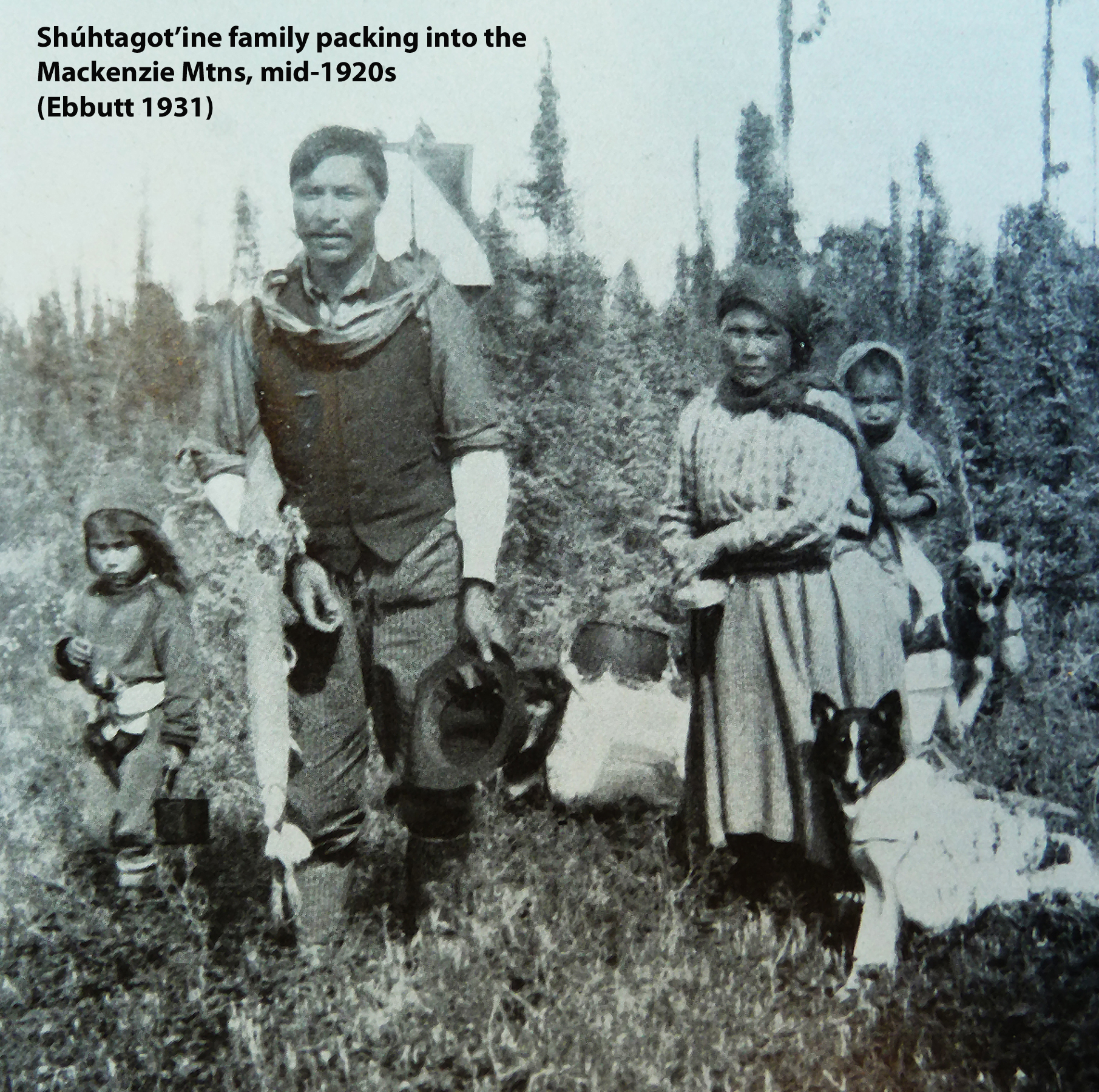
II. Historical, derived
from oral histories supplemented by written and
photographic records (1800 to 1941):
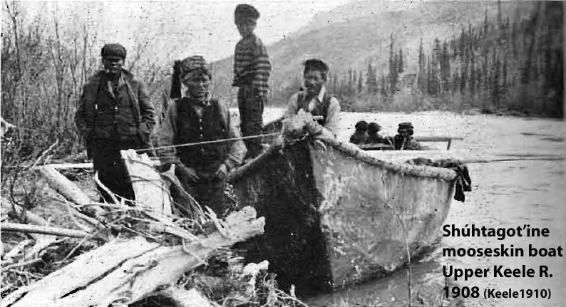
In 1789, Alexander Mackenzie canoed the Decho River which now
bears his name. His was the first published record of this
region and included a note about petroleum seeps in the
vicinity of Norman Wells. The fur trade followed as did
missionaries and other components of European culture. First
Nations people made an annual journey into the mountains to
hunt, fish, trap and harvest plants. Later, diseases caused
population crashes and social services such as religion,
education, and health led to the establishment of Tulita, Ft.
Good Hope, and Déline. In 1918-19 the “discovery” of oil led
to the settlement of Norman Wells and eventually a small
refinery to supply fuel needs in the valley. The
Mackenzie Mountains Game Preserve was established to conserve
game primarily for First-Nations and Métis hunters.
III. CANOL Project, short-lived but permanently impacted
the land
(route selection Oct-Nov 1942 & Apr 1943;
construction start Dec 1942 & salvage 1948-53):

Rudimentary surveys of the east end of the
potential CANOL No.1 pipeline route occurred as early as
summer 1942. Several attempts at construction on a route up
the Carcajou R were later abandoned as a better route was
suggested by local Shúhtagot’ine (Mountain Dene) familiar with
the Mackenzie Mountains. Commencing October 1942 Fred
Andrew, George Blondin and [Little] Edward Blondin, driving
dog teams, guided the surveyor Guy
Blanchet along traditional routes, arriving at Sheldon
Lake YT in late November.
Construction of the above-ground pipeline, telephone line (not
telegraph) and service road took more than a year. There is a
very informative account of the construction, particularly the
telephone line by Milford Flood
(October 1943 to April 1944). The project was abandoned in the
spring of 1945 prior to breakup. As early as 1947 salvage
operations were conducted and the last organized efforts were
in the Mackenzie Mountains in 1953. A total of 1.2 million
imperial barrels of crude oil were pumped from Pump Station
No. 1 over a 13 month period.
IV. Current (1954 to present):
The Mackenzie Mountains Game Preserve was abolished in 1953 and
the Mackenzie Mountains was opened to trophy hunting in 1965.
Two of the outfitters’ territories include sections of the
abandoned CANOL Project. In 1994 the land base for a Canol
Heritage Park was reserved in the Sahtu Dene and Métis Land
Claim Settlement Act. Mineral exploration and staking of
claims have been ongoing throughout the region since prior to
the CANOL Project with several significant properties mothballed
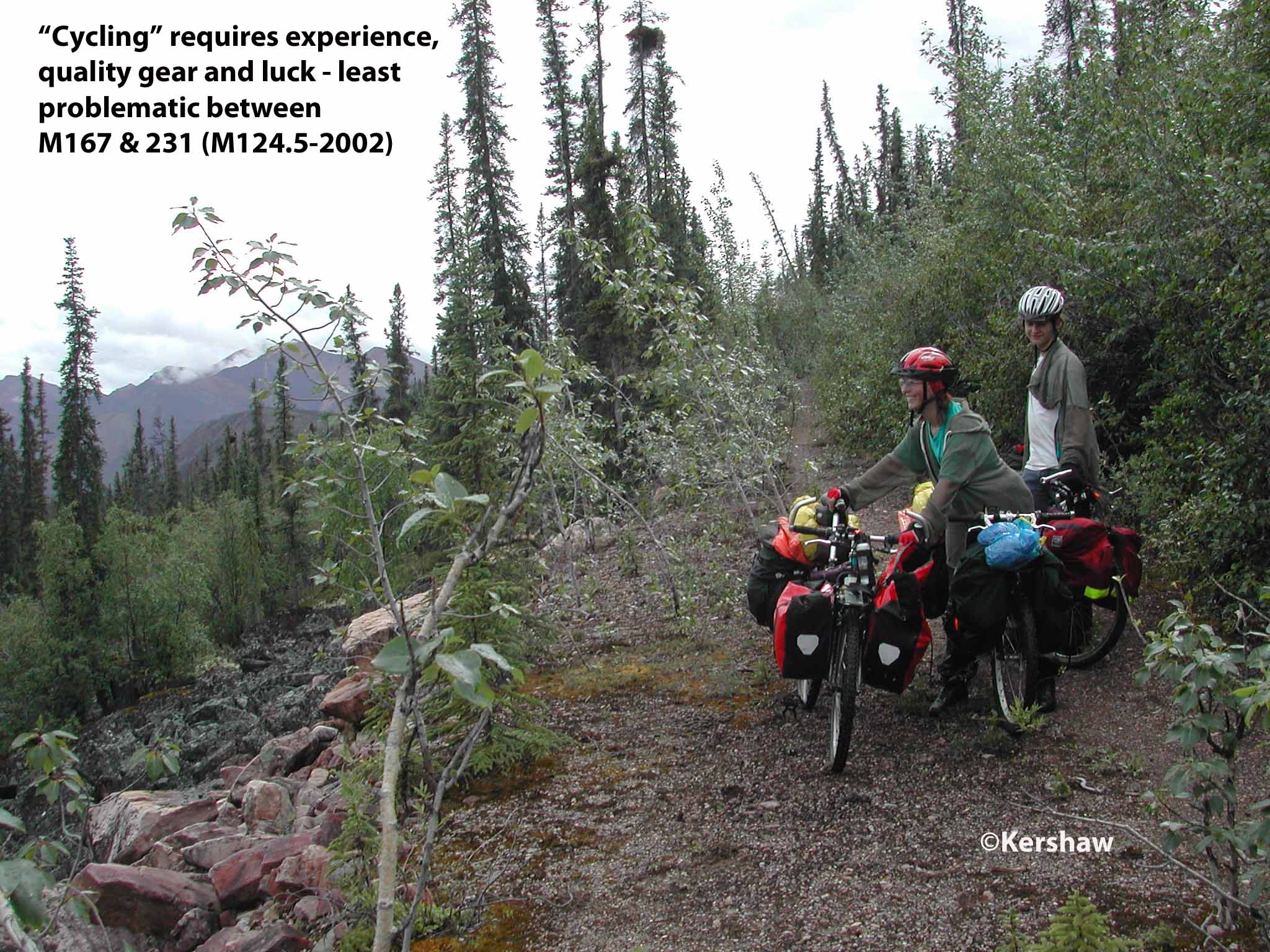
or currently being assessed. Recreational use has been
light with few people on the trail at any given time.
All-terrain vehicles are active on both ends of the trail and
snowmobiles frequent the northern (Norman Wells) end.
Meat/subsistence hunting has been common where there is vehicle
access. A naturalist lodge, Dechen la' Lodge and
Wilderness Resort, has facilities between Caribou Pass and Camp
222 while Canol Outfitters are based at Godlin Lakes. With the
removal and/or boarding-up of Canol buildings, users must rely
on their own shelters, however the Government of the Northwest
Territories has erected shelters at M1, 8, 49.5, 75 and 100)
with the possibility of more in the future (M125 and 150 slated
for 2021).
Citation/Illustration Sources:
- Andrews, T., MacKay, G., and
Andrew, L., 2012: Archaeological investigations of
alpine ice patches in the Selwyn Mountains, Northwest
Territories, Canada. Arctic, 65:1-21.
- Ebbutt, F., 1931: The Gravel
River Indians. Canadian Geographical Journal, 2:310-321.
- Finnie, R. S., 1945: Canol, the
sub Arctic Pipeline and Refinery Project constructed by
Bechtel Price Callahan for the Corps of Engineers, U.S.
Army 1942-44. San Francisco: Bechtel Corporation, 210
pp.
- Keele, J., 1910: A
reconnaissance across the Mackenzie Mountains on the
Pelly, Ross and Gravel Rivers, Yukon Territory and
Northwest Territories, Publ. 1097. Ottawa: Geological
Survey of Canada, 54 pp.
- Mackenzie, A., 1801: Voyages
from Montreal On The River St. Lawrence Through The
Continent of North America to the Frozen and Pacific
Oceans in the Years 1789 and 1793. Reprinted 1971.
Edmonton: M.G. Hurtig Ltd., 412 pp.
Contact/Correspondence
to: CANOLhiker@gmail.com
Updated: 20210331